
Collection Facts
Scope of Collection
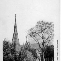
A collection of historic photographs of local subjects from Washingtonville, and Blooming Grove’s past, including community members, landmarks, and events.
Browse within this collection
Browse similar collections


Collection Facts
Historical Context
Sheet music is music that has been handwritten or printed on paper and uses modern musical symbols to indicate chords, melodies, and rhythms of a song. During the nineteenth century, sheet music was the most dominant type of music in the music industry.
Scope of Collection
This collection contains documents and images of sheet music that was played during the nineteenth and twentieth centuries.
Browse within this collection
Browse similar collections

Collection Facts
Historical Context
Ward Manor was a 900-acre estate in Red Hook on the Hudson River, named after William Boyd Ward, grandson of the founder of the Ward Baking Company, who purchased it in 1926. He immediately donated it to a charitable organization, the Association for Improving the Condition of the Poor, "for the establishment and maintenance of a home for the aged, a home for convalescents, and summer outing camps." Summer camps for girls and boys were operated through the 1950s. Bard College purchased the property in 1963.
Scope of Collection
This collection belonged to a Ward Manor camper named Sadie Francaviglia. It includes postcards and photographs of the buildings, grounds, staff and campers taken in the late 1920s.
Browse within this collection
Browse similar collections


Collection Facts
Historical Context
In 1926 William Ward of the Ward Baking Company funded the renovation of the river estate known as Almonte for purposes of creating a home for the elderly in the 'gray manor house', to be managed and run by his friend William Matthews. Soon, Matthews extended the operation to include summer camps for girls and boys, and summer bungalow rentals to poor families in some 56 buildings extending from Cruger's Island, through what is now Tivoli Bays, to the "Homestead" mansion at the southern edge of the village of Tivoli.
Scope of Collection
This photograph collection, owned by William Matthews' grandaughter Donna Matthews, document the activities and the lives that were led at Ward Manor for more than 30 years.
Browse within this collection
Browse similar collections


Collection Facts
Historical Context
The War of 1812 is also known as America’s Second War for Independence. Many battles were fought on the Niagara Frontier and in Upstate New York.
Scope of Collection
This collection features letters written during the War of 1812, as well as letters written after the war ended recalling war-time regional circumstances.
Browse within this collection
Browse similar collections

Collection Facts
Historical Context
Historical Background
The War of 1812 is barely acknowledged in American social studies textbooks. It remains an obscure and little understood period of American history, falling between the traditional thematic divisions of the American Revolution and Jacksonian Democracy. For most people, the War of 1812 is simply recognized as the inspirational moment that gave America the Star Spangled Banner, as Francis Scott Key witnessed from a British ship the resolutely waving flag amidst the conflict at Fort McHenry in Baltimore; generated the dramatic narrative describing the legendary heroic feat of Dolly Madison, who rushed to gather up and save White House treasures just moments before the British burned down D.C.; and established Andrew Jackson as a military leader by his postwar victory (the Treaty of Ghent had already been signed, ending the war) at the Battle of New Orleans—a feat that subsequently earned him the Presidential election in 1829.
Aside from these iconic associations with the War of 1812, the global consensus is that the conflict was a minor hiccup in the greater ongoing struggle between Britain and France, its significance dwarfed by the almost simultaneous occurrence of the end of the Napoleonic Wars that brought about great changes in nineteenth century Europe. What are not as evident from the traditional historical interpretations of this time period are the great and lasting changes the War of 1812 brought about in the North American landscape. The nation of Canada was forged from the experience, and the many nations of Native people began to disappear from the North American map. While the Treaty of Ghent may have restored the European status quo antebellum, it forever transformed the North American landscape as the Treaty purposefully excluded Native Americans in the postwar settlement agreements, and the experience of the war left colonists in Canada with a new sense of unity and pride.
Both the British and the Americans had depended on Native American support in the conflict. Many Seneca, Onondaga, Oneida and Tuscarora of the Six Nations Confederacy fought with the Americans, while the Mohawk sided with the British. According to research done at the National Archives:
More than 1,000 Native Americans served during the War of 1812. They were organized in more than 100 companies, detachments, or parties. About half were Choctaws, and half were either Creeks or Cherokees. Units from other tribes included Blue's Detachment of Chickasaw Indians (discussed below), Capt. Wape Pilesey's Company of Mounted Shawano Indians, and Capt. Abner W. Hendrick's Detachment of Stockbridge Indians. (source: Collins, Prologue Magazine, Winter 2007, vol.39, no.4, paragraph 5)
Further west, along the Great Lakes border areas, the Indians under Tecumseh's leadership became allies with the British against the United States. The Potawatomi, Menominee, Ho-chunk, Ojibwa, Ottawa, Santee Dakota, Sauk, and Fox all fought as British allies in the War of 1812. Many of these First Nations had allied themselves early on with the French, but following British victory over the French in the War for Empire (French and Indian Wars), many of the Native communities now saw the British presence as the only wedge to keep the American settlers from advancing into their territories in the West and South. The Treaty of Ghent acknowledged not one concession to any Native American nation, even though several promises had been made during the conflict. Without British influence to preserve their land claims in negotiations, and with no formal or legal authority to recognize their role in the conflict, Native Americans were subsequently forced to endure a long and painful period from the end of the conflict up until at least the beginning of the 20th century, in which they would lose people, land, and dignity.
The alliances between Native Americans and the British in the War of 1812 increased hostile relations between some Native Americans and American citizens. This tension ultimately served to strengthen negative attitudes among American citizens, extending to more and more hostile government policies of the state and federal governments, often resulting in removal of Native people from their lands. Accounts of the deteriorating relations between Native people and Americans are numerous and can be found in records at local, state, and national repositories (see for example: Red Jacket Rejects Sale of Buffalo Creek Reservation: July 9, 1819, from SUNY Oswego's Granger Collection, andChronicles of Oklahoma, Indian Removal, from Oklahoma Historical Society).
Following the American Revolution, the British loyalists who fled to what was then known as Upper Canada, had integrated themselves into British and French settlements that were now operating under British rule. When war broke out between the Americans and British, many colonists in Canada saw this as yet another affront to their British rulers. At the same time, American leaders and citizens were entertaining ideas of invading and taking Upper Canada from British control to counter the longstanding British foothold in Montreal and Quebec that allowed the British to continue to operate with force on the continent. The British strategy was to employ their superior naval strength to counter Americans along the eastern seaboard areas, specifically in the South (New Orleans), mid-Atlantic (Baltimore), and Hudson Valley (via the Great Lakes and Seaway), with the goal of driving a wedge between American forces in the North and South.
The British colonists of Canada, recognizing their precarious situation as a target for American forces hoping to cripple British naval superiority, rallied together to combat the invaders. To this day, Canadian history portrays with much patriotism the heroism of Colonel Brock and the Canadian forces at the Battle of Lundy’s Lane, much as American history recounts colonial forces overcoming great odds against the British army in the battles of the American Revolution. In the aftermath of the conflict, Canadian colonists struggled with the British government to gain more opportunities for self-governance, peaking with the 1837 Patriot War, resulting in the Unification of Canada in 1840 and, ultimately, independence for the nation in 1867.
War of 1812 in Western New York
In terms of local activity, the War of 1812 left an indelible mark on the physical, social, and political landscape. In her book, A History of the Town of Amherst, New York, 1818-1965 (*also found on New York Heritage here), former Town Clerk & Historian Sue Miller Young writes that during the War of 1812, American troops were stationed in Williamsville in the area between Garrison Road and Ellicott Creek. American soldiers and British prisoners were treated in a field hospital and log barracks that lined Garrison Road. A small cemetery, located on what is now Aero Drive, between Wehrle Drive and Youngs Road, was used to bury the men who did not survive their wounds or illnesses. General Winfield Scott used the Evans House (demolished ca. 1927) as his headquarters in the spring of 1813, when his entire army of over 5,000 men was stationed in Williamsville. Later the same year, when the British burned Buffalo, people fled to the safety of Williamsville and nearby Harris Hill.
Another local landmark is the site of the Flint Hill Encampment. The Army of the Frontier under General Alexander Smythe set up camp at Granger's farm during the winter of 1812-1813 in anticipation of invading Canada. Nearly 300 soldiers died there of camp disease. Farmers Daniel Chapin and Rowland Cotton were left to bury the dead in Granger's meadow, known today as Delaware Park (source: Historic Markers, Monuments, and Memorials of Buffalo, New York). For a long time after the conclusion of the War of 1812, American and British-Canadian relations remained strained and guarded. For this reason, the U.S. Army maintained a camp at Poinsett Barracks in Buffalo (now the location of the historic Wilcox Mansion on Delaware Avenue). The War of 1812 was and remains an important part of First Nations, Canadian, American, and local history.
Additional Resources
An American Time Capsule: Three Centuries of Broadsides and Other Printed Ephemera (Library of Congress)
British-American Diplomacy War of 1812 and Associated Documents (The Avalon Project, Yale Law School)
Early Canadiana Online
Free eBooks: War of 1812 (Digital Book Index)
Galafilm War of 1812
Guide to the War of 1812 (Library of Congress)
Native Americans in the Antebellum U.S. Military (National Archives)
Native Americans Mustered into the Service of the United States in the War of 1812 (USGenWeb Project)
Official War of 1812 Bicentennial Website
Re-living History: The War of 1812 (ThinkQuest)
Revolutionary War and War of 1812 Historic Preservation Study (National Park Service)
War of 1812: An Introduction
War of 1812 images from NYPL Digital Gallery (New York Public Library)
Local Resources
Biographical Sketch of the late Dr. Cyrenius Chapin (The Buffalo Medical Journal, vol.8, 1868-1869)
Buffalo History Museum Research Library
Buffalo Architecture and History, The History of Buffalo: A Chronology - 1812
Burning of Buffalo, N.Y.: December 30, 1813
Genesee County Military Notebook Collection (see War of 1812 notebook listings)
Historic Markers, Monuments, and Memorials of Buffalo, New York
Lewiston Public Library, Genealogy/History Room
Niagara Falls Chronicles of Our Early Settlers (see War of 1812 section)
Pictorial Field-Book of the War of 1812, by Benson J. Lossing (NY: Harper & Brothers, 1868)
Town of Cambria, Historian (see War of 1812 section)
War of 1812 Cemetery, Town of Cheektowaga, Erie County, New York
Scope of Collection
This collection is drawn from a larger body of materials at the Buffalo History Museum that documents both the local and broader historical period during the War of 1812. Materials include original and published letters, journals, diaries, scrapbooks, reminiscences, news clippings, and other ephemera concerning the conflict from both a local and more general perspective.
Browse within this collection
Browse similar collections

Collection Facts
Historical Context
The need for a schoolhouse for the children of Jerusalem farming village was begun in 1876. Land was acquired from John Birdsall Garner’s farm for a one room schoolhouse off North Jerusalem Ave. in what is now South Levittown. The school had an additional two rooms added across the front of the original building facing Wantagh Ave. Today this schoolhouse is a Town of Hempstead landmarked building and is used as a Pre-K facility.
In 1904 a second school building was erected at 1865 Beech St. (originally Seymour Ave.), for teaching Elementary grade students in the recently renamed village of Wantagh, 4 miles South of the old Jerusalem schoolhouse. In 1909 that school was replaced by a larger structure and used as an elementary school until 1958. It continued to be used as a school district administration office until 1982. Today it is leased to the Wee Friends Nursery school and Day Camp for Pre-K children.
In 1928, voters approved $ 230,000.00 in bonds to be used for a site at Walters Ave. and Cypress St., to build an eight-classroom building, later called the Sunrise Park school. After many years of use, this building was torn down and replaced with houses in 1989, due to a shrinking student population.
After World War II a housing boom took hold in Wantagh and other surrounding communities. In Wantagh from 1949 to 1950 the student population went from 860 students to 1334 students, using a split session schedule due to overcrowding. In 1950 a new 14 classroom elementary school was built on farmland acquired from the Boos' family. The new Wantagh school on Beech St., was used for kindergarten classes and grades 2-5. First graders remained at the Seymour school. Grades 6-8 went to classes at the Sunrise Park School. Even with a new school the student population was growing too large for the buildings.
In 1952 Wantagh citizens approved adding 21 rooms to the Wantagh school and 12 rooms to the Sunrise Park school. The citizens also approved buying land on Beltagh Ave. near the Wantagh Parkway for a High School and 3 million dollars for its construction. The High School was completed in 1955 and the student grades were rearranged on a temporary basis. That year citizens approved the purchase of two parcels of land that would become the sites of Mandalay and Forest Lake elementary schools during the end of the decade. By 1965 a junior high school had been completed next to the High School and all the elementary grade children now went to Mandalay, Forest lake, Wantagh and Sunrise Park schools.
The school system of Wantagh has provided academic, athletic and cultural arts programs of an excellent reputation to it’s students for the past seven decades. The district’s curriculum has enabled a high percentage of Wantagh’s students to pursue college educations in specialized fields of study to our societies benefit as well as their individual benefit.
Scope of Collection
Photographs and documents of school programs, including dedications of the new school buildings, sporting events, concerts, drama programs and other ephemera. This collection spans from the early 1900s to the present.
Browse within this collection
Browse similar collections

Collection Facts
Historical Context
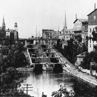
During the 1960’s the LIRR continued a modernization plan of elevating the railroad tracks of its Babylon trunk line in Nassau County’s South Shore. The project embraced a number of villages at this stage of the upgrade including, Merrick, Bellmore, Wantagh, Seaford and Massapequa Park. Massapequa had been raised at an earlier period. It’s believed Rockville Centre, Baldwin and Freeport stations were raised during the 1950’s.
The project began in Wantagh in 1965 with the laying down of temporary tracks slightly South of the original tracks. In 1966 the old Wantagh station was donated to the Wantagh Preservation Society and moved to a location a half mile North of the tracks on Wantagh Ave. The grand opening day was October26,1968 and the temporary tracks were removed by November,1968.
In 2000 the ground level part of the station ticket and waiting area underwent a modernization.
From 2016 to 2018 the elevated platform of the station was replaced with a new waiting area, escalators and an elevator.
Scope of Collection
The bulk of this collection of photos was taken by Warren Hiltonsmith during the time of the grade elimination project. Warren and his wife Marion Hiltonsmith were founding members of the Wantagh Preservation Society. He also served as president of the society.
In addition to the elevation project, he also took pictures of the restoration of the original Wantagh railroad station at its new park setting. Along Railroad Ave a number of buildings were demolished due to the elevation project. Mr. Hiltonsmith documented these buildings with snapshots.
Browse within this collection
Browse similar collections

Collection Facts
Historical Context
This collection of pictures identifies men, women and children living in Wantagh from the nineteenth century to the present day. Some well-known people, and some were members of Wantagh families with deep roots in the community, going back generations. Others were business people in the village.
Scope of Collection
Portraits and pictures of the people of Wantagh through the decades. Photos are color and black and white. Newspaper articles and other ephemera.
Browse similar collections

Collection Facts
Historical Context
In 1643 Captain John Seaman and Robert Jackson crossed the Long Island Sound from Stamford, Connecticut and purchased 6,000 acres from the Mericoke and Marsapeaque Indians living in the area that today comprises Wantagh and Seaford. In 1644 Robert Jackson built the first dwelling in the area that still exists today.
Jackson was elected a delegate to the Duke’s Law Convention in 1665 and became one of Hempstead’s founding fathers. In 1666 a charter was given to the settlers of the area that they named “Jerusalem “(Today’s North Wantagh/South Levittown). The original name for the area was influenced by the Quakers that settled and farmed the land.
The South Shore Railroad arrived in South Jerusalem in 1867 and named the community’s depot Ridgewood Station. The U.S. Post Office refused to recognize the area for a Post Office because a town named “Ridgewood” already existed in Western Queens County (The three Eastern towns broke away and became Nassau County on January 1, 1899).
In 1891, the members of the Congregational Church held a contest to rename the village and “Wantagh “was chosen. Wantagh was a Sachem (chief) of the Montauk Indians.
For the 17th, 18th and 19th centuries Jerusalem was a rural farming community that also provided fishing and hunting excursions to residents of nearby New York City. The 20th century brought tremendous changes to Wantagh, as the village became a vacation destination during the summer for city dwellers between the world wars. After World War II the need for housing for returning veterans brought about an explosion of home construction resulting in a new living environment now called Suburbia. The last of the farms disappeared into housing developments and the settlement of Jerusalem faded away to become North Wantagh and South Levittown (named after the family construction company of many of the new housing developments).
Wantagh today is a vibrant community that provides its citizens with many diversions to recreation such as “Jones Beach “, athletic fields and parks for boating and pools. As well as churches, restaurants, shopping, excellent schools and convenient transportation.
Scope of Collection
Pictorial history of Wantagh, New York during the 19th and 20th centuries.